Accessible satellite data decision support systems for Yurok Tribe forest management
Members of the Engineering Systems Laboratory engaged stakeholders from the Indigenous Yurok Tribe in California to create a user-friendly decision support system for forest management.
Authors: Seamus Lombardo, Javier Kinney, Dawn Blake, Shaonna Chase, Atticus Stovall, Afreen Siddiqi, Katya Arquilla, Steven Israel, Danielle Wood, Olivier de Weck
Citation: Acta Astronautica, Volume 213, December 2023, Pages 777-791, ISSN 0094-5765
Abstract
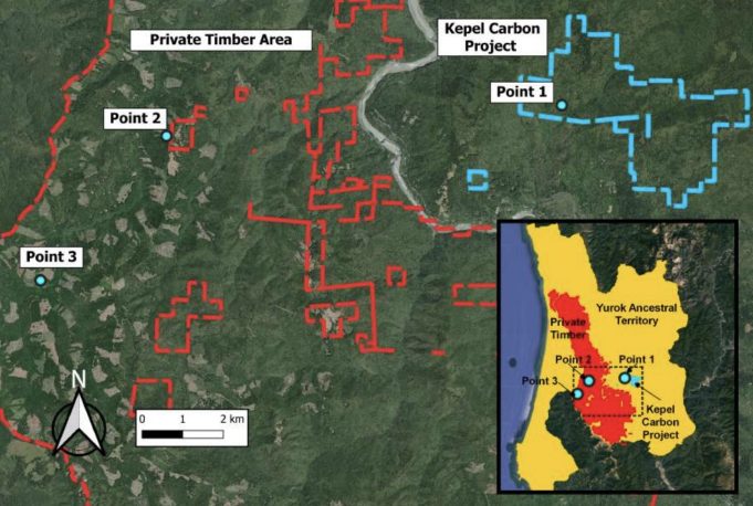
Local decision makers managing forests for sequestering carbon and mitigating disturbance face increasing pressures from climate change, while needing to derive revenue from forest resources and balance diverse stakeholder concerns. Decision support systems (DSS) that use freely available satellite data are effective tools for forest management decision-making, due to the broad spatial coverage and temporal consistency of this data. However, the literature demonstrates that many DSS developed by researchers incorporating satellite data are often not utilized by decision makers. This is in part due to a lack of stakeholder engagement in DSS development. Here, we employ an intentional stakeholder engagement process to develop an accessible DSS incorporating satellite data. This process is applied with the Yurok Tribe – an Indigenous community in California – towards the goal of managing forests for carbon sequestration. We use system architecture framework (SAF) to translate stakeholder objectives into targeted analyses and the environment-vulnerability-decision-technology (EVDT) integrated modeling framework to incorporate contextual local infrastructure and land ownership information alongside satellite data analyses. Satellite data analyses classify tree cover and track Normalized Difference Vegetation Index (NDVI) over time. We compare and show that trends in our analysis agree with independent global tree cover and biomass datasets. These analyses meet the Tribe’s objective for tracking forest trends in Yurok carbon sequestration projects, while also detecting undesirable conifer encroachment on culturally-important prairies traditionally managed as open landscapes. Additionally, integration of community infrastructure data alongside satellite-derived drought, forest fire, and smoke density information via EVDT meets another Yurok Tribe objective of identifying negatively impacted Tribal areas for aid allocation. User feedback sessions with participating Yurok Tribe employees assess the prototype DSS and show 80% of users providing high ratings (≥75%) for information accuracy, relevancy, and sufficiency, demonstrating that our DSS development process overcomes previous gaps to DSS use and satellite data accessibility to augment Yurok Tribe forest management decision making.