Visibility metric for planning SAR observations in challenging terrain
PhD student Evan Kramer and Prof. David Miller in the Space Systems Laboratory introduce a systematic and general method for identifying observation geometries that optimize visibility for any region of interest, regardless of its shape or location.
Authors: Evan L. Kramer, David W. Miller
Citation: IEEE Transactions on Geoscience and Remote Sensing, vol. 62, pp. 1-14, 2024, Art no. 5226114
Abstract:
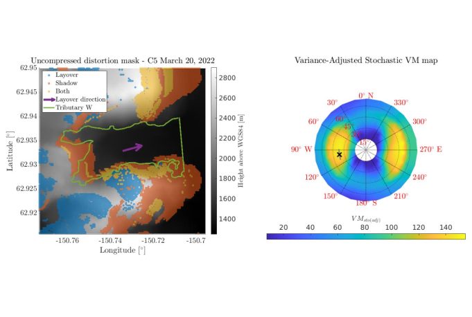
Accessibility to space-based synthetic aperture radar (SAR) imagery is rapidly increasing, thanks to the recent advent of commercial SAR constellations. Not only are SAR data collected more frequently but also flexibility in specifying acquisition parameters is improving. While SAR satellites can acquire reliable imagery, the relative geometry between the local terrain and the SAR sensor causes portions of the acquired imagery to be obscured due to layover and shadow geometric distortions. Currently, no systematic and generalizable method for planning maximally visible SAR observations in challenging terrain exists. The utility of SAR imagery in challenging terrain is, therefore, limited.
To address this limitation, this article presents the first systematic and generalizable approach to determining observation geometries with favorable visibility conditions for an arbitrarily shaped region of interest (ROI) at any location. An extension to the open-source NASA/JPL InSAR scientific computing environment (ISCE) software was developed to enable the simulation of geometric distortion masks from all possible observation geometries. Three visibility metrics (VMs) are formulated to serve as a means of quantifying ROI visibility and comparing multiple observation geometries. Implementation of the VMs is demonstrated on a simple imaging scenario to highlight the benefits of stochastic VM formulations in the presence of topographic model uncertainty. Finally, the VMs are implemented in a glacier extent mapping scenario using real SAR imagery and satellite data to demonstrate their utility in observation scheduling operations. In the presented scenario, nearly 50% more ROI visibility could have been achieved if VMs were integrated into the observation scheduling process.

